Inside GalaxEye's Drishti: The Physics of the World's First OptoSAR Satellite
GalaxEye's ~190 kg Mission Drishti co-locates X-band SAR and a 7-band multispectral imager on one bench, fusing them in orbit. The SyncFusion architecture kills ground-station fusion latency and underwrites a defensible Earth-observation moat.
Manik Gupta
Founder and editor of DeepTech India. Manik writes about India's frontier technology ecosystem — AI, semiconductors, space, quantum, robotics and biotech — translating research and policy into clear, reliable reporting.
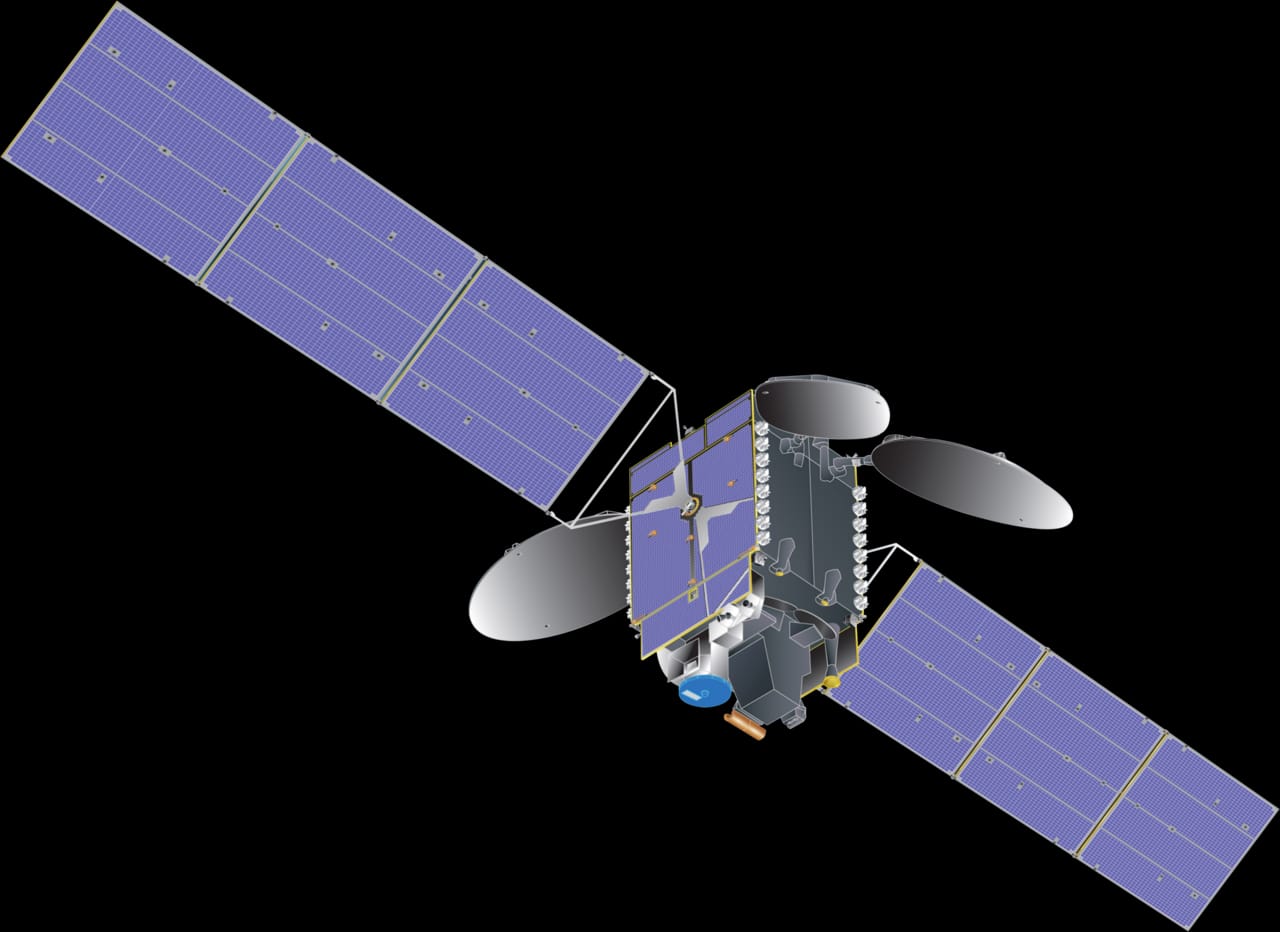
On 3 May 2026, a roughly 190 kg satellite named "Mission Drishti" separated from a SpaceX Falcon 9 over the Pacific and slipped into a 500±10 km Sun-synchronous low Earth orbit. The launch, from Space Launch Complex 4E at Vandenberg, was unremarkable as a rideshare. The payload was not. GalaxEye, a Bengaluru startup spun out of IIT Madras, describes Drishti as the world's first commercial "OptoSAR" satellite and India's largest privately built Earth-observation spacecraft. The interesting part is not the mass or the rocket, but that GalaxEye has put two fundamentally different ways of seeing the planet onto a single optical bench and fused them in orbit, attacking a problem the industry has spent two decades working around.
Two ways of seeing, each half-blind
Earth observation has historically forced a choice between two sensing physics, and each is crippled in a way the other is not.
The first is multispectral imaging, or MSI. A multispectral imager is a passive sensor: it collects sunlight reflected off the surface, split into discrete wavelength bands. Because different materials reflect and absorb light differently, MSI yields intuitive, human-legible imagery, true colour, vegetation health from the near-infrared, water turbidity from coastal bands. It is the data an analyst can read at a glance. Its weakness is its dependence on the very thing it measures. No sunlight, no image, so it is dark at night. Worse, it cannot see through cloud, and at any moment a large fraction of Earth's surface, most of the tropics through the monsoon, is under cover. For applications needing reliable, scheduled observation, agriculture, disaster response, maritime surveillance, an optical-only sensor is a fair-weather instrument.
The second is Synthetic Aperture Radar, or SAR. SAR is active: the satellite illuminates the ground with its own X-band microwave pulses and times the echoes. Because it supplies its own energy and microwaves pass through cloud and rain, SAR sees day or night, through weather, every pass. "Synthetic aperture" is the trick that makes it useful. A real radar antenna small enough to fly would have hopeless angular resolution, so SAR uses the satellite's own along-track motion, coherently combining echoes over a long flight path to synthesise a virtual antenna kilometres long, delivering fine resolution from a small sensor. The cost is interpretability. SAR returns are specular, dominated by surface geometry and dielectric properties, so the imagery is grainy, speckled and counter-intuitive: a metal roof can flare brighter than a city block. SAR tells you structure and change; it struggles to tell you what a thing is. Neither sensor is sufficient alone, so the obvious answer is to combine them, and the industry has tried.
Why ground-based fusion is broken
The standard approach is to operate separate SAR and optical constellations and fuse their outputs on the ground, after the fact, and this is where the physics bites, because two satellites looking at the same patch of Earth never truly see the same thing. They image from different positions and look angles, which injects parallax: tall structures and terrain shift relative to the background with viewpoint, so a building's radar footprint and its optical image do not overlay cleanly. They almost never pass overhead simultaneously, which injects temporal misalignment: hours or days separate the two captures, and in that gap ships move, floodwater spreads, crops change. Fusing a Tuesday radar frame with a Thursday optical frame yields a composite that describes no single moment. Post-capture co-registration can warp and resample to partially correct geometric offset, but it cannot recover information that was never co-temporal, and every correction step adds error and latency. The result is "analysis-ready" data that arrives late and carries baked-in registration uncertainty, which for time-critical use, a tactical maritime picture, an active flood, is exactly where the value leaks out. GalaxEye's bet is that the only fix is to stop fusing two satellites and instead build one.
SyncFusion: co-located sensing and onboard registration
The core of Drishti is what GalaxEye calls its SyncFusion stack, and the first principle is physical: the X-band SAR sensor and the multispectral imager share a single, thermally stable optical bench. Mounting both instruments on one rigid, temperature-controlled structure means they observe the same scene from the same vantage at the same instant, collapsing the parallax and temporal-alignment problems at the source. The multispectral payload is a 7-band imager, spanning Panchromatic, RGB, Near-Infrared, Coastal Blue and Red Edge. The band choice is deliberate: Coastal Blue penetrates shallow water and aerosols, Red Edge is the canonical band for vegetation stress, and the high-resolution Panchromatic channel pan-sharpens the colour bands.
Sharing a bench is necessary but not sufficient, because no spacecraft structure is perfectly rigid. Launch loads, thermal cycling as the satellite crosses the day-night terminator, and micro-vibrations from reaction wheels induce mechanical jitter, tiny shifts between the two sensors' lines of sight, and at metre-scale resolution even sub-pixel misregistration smears the fused product. So SyncFusion runs sub-pixel co-registration onboard, in real time: the processor measures the residual offset between the radar and optical frames and resamples them into precise alignment before combining, correcting the jitter the rigid bench cannot fully suppress. The fusion then overlays SAR-derived structure, edges, change, sub-surface and through-cloud returns, onto the optical layer's material and colour information, so one product carries both "what is there" and "what shape it is", co-temporal and co-registered.
The output is analysis-ready imagery at 1.2-3.6 m resolution on a 4-day revisit, with the fusion already done in orbit. That last clause is the commercial crux. Competitors deliver raw layers for the customer to fuse, or fuse in a ground pipeline that adds hours; Drishti downlinks a product already merged, registered and interpretable.
Unit economics, moat and the comparables
The investment case rests on a constellation, not a single satellite; one spacecraft on a 4-day revisit is a demonstrator. GalaxEye's plan is a 10-satellite constellation by 2030, compressing revisit toward sub-24 hours. Revisit governs Earth-observation unit economics: a daily-or-better cadence converts the offering from occasional snapshots into a monitoring service, and monitoring is what defence, insurance, commodities and agriculture pay recurring money for. More satellites also amortise the fixed SyncFusion IP across more captures, improving margin as the fleet scales.
The company has raised more than $20 million from a backer list that doubles as distribution and credibility, Speciale Invest, Mela Ventures, Infosys, drone-maker ideaForge and Rainmatter, the climate-tech arm of Zerodha. The natural comparables are Finnish SAR operator ICEYE, last valued around $2.8 billion, and US imaging incumbent Maxar. GalaxEye's differentiation against both is not resolution or constellation size, where it is outgunned, but architecture: co-located, in-orbit fusion that removes the ground-based stitching step its rivals still depend on. If that yields lower-latency, higher-confidence analytics, it is a genuine moat wherever fusion latency is the binding constraint. Led by CEO Suyash Singh, GalaxEye has also signed a data-distribution partnership with NSIL, ISRO's commercial arm, handing an early-stage startup an institutional channel to government and enterprise buyers, per the mission portal and reporting from Business Standard, The Federal and Swarajya.
The honest caveats are those that attend any first-of-kind orbital system. "World's first OptoSAR" is a single satellite that must now prove its fused products perform at the claimed resolution and registration accuracy across diverse scenes and seasons. Onboard real-time fusion is computationally demanding, and power, thermal and downlink budgets on a ~190 kg bus are finite. The 10-satellite, sub-24-hour vision depends on capital, manufacturing cadence and launch access through 2030, none guaranteed for a firm that has flown one spacecraft. But the thesis is precise and testable, not hype: GalaxEye has not built a better SAR or a better optical satellite. It has built the one that fuses them where the problem actually originates, in orbit, on a shared bench, before the data ever reaches the ground.
Tags
More from Space Technology
Agnikul's Four-Engine Cluster Test and the Electric-Pump Bet on Cheap Orbit
Agnikul Cosmos ground-tested a four-Agnilet cluster, using an electric pump-fed cycle to turn thrust-matching into software-defined throttling. With a $500M-plus valuation and ICEYE and Safran MoUs, it de-risks a targeted late-2026 orbital launch.
The ePlane Company Clears DGCA's Design Bar as It Lines Up a Series C
The ePlane Company is the first private Indian entity to win a DGCA Design Organisation Approval for its e200X eVTOL, a durable regulatory moat now anchoring a planned $40-50M Series C toward fleet commercialisation.